Aerophoto map of Sofia
Submitted on Tuesday, 24 February 2009No Comment
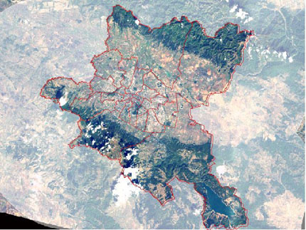
A new internet map of Sofia, created by using aerophotographs, is published on the website of the Geographic informational system (GIS).
Aerophotographs were taken of the whole territory of the Sofia municipality. They were ordered by the municipality firm “GIS-Sofia” Ltd. The pictures were taken between April and May 2008.
The map is uploaded of the website of the firm as an additional thematic map in the informational system for online access to the cadastre of the municipality of Sofia, iSofMap.
The images show the current condition of the environment with a resolution 1m. The visuals are the same as those of a satellite photograph.